Even 30 years after it officially ceased to exist, it’s still the one everybody talks about when they talk about the open road. Whether you call it the Mother Road, America’ Main Street, old U.S. 66 or Historic Route 66, it still has that sense of freedom. Its longevity in American culture is nothing short of amazing. It’s as if it is hardwired into our psyche.
Route 66 wasn’t the longest or the first highway in the nation but it was, and still is, the road every one associates with American travel. Maybe it’s because of where the road went… from the Windy City to the City of Angeles; from the cold, blustery shores of Lake Michigan to the warm and balmy beaches of ‘the coast’. Or maybe it’s because it was the first highway marked well enough that it could be followed all the way.
But it could also be because this road, like no other, linked all of the small towns and villages it passed through or close to in a way never before possible.
Route 66 had a few things going for it from the outset. It offered a route with better weather than the other east-west highways and it was far easier to navigate. It was reasonably flat and easy to drive with only a few mountainous stretches. The only truly scary section of road was approximately 20 miles around the gold mining town of Oatman, AZ. With its heady changes in elevation, its tight, blind hairpin turns and narrow switchbacks, this section of the highway presented the less-skilled driver with a daunting task. Many travelers chose to hire local drivers to get them safely through the area. (This alignment of Route 66 is still used daily by locals.)
In 1938, 10 years after it opened, Route 66 became the first national highway to be paved from beginning to end, making it the first all-weather national road. The traffic floodgates fully opened. Car traffic increased some but truck traffic grew by leaps and bounds. Manufacturers could move their products across the West with relative safety and dispatch. During World War II, Route 66 allowed the efficient movement of soldiers and materials to the West Coast along with thousands of defense workers to the plants in the West.
After the war ended, thousands of former GI’s returned to civilian life and were ready to hit the road. Along Route 66, travel services grew at what seemed lightning speed. The drive-in restaurant developed. Fast food got the traveler back on the road quickly. The auto camp became the motor court. The motor court became the tourist home which in turn became the motor hotel with individual cabins. The motor hotel evolved into the motel with a swimming pool and a restaurant. The gas station became the auto service center. The restaurant, service center and motel combined to become the full-service travel oasis.
And they kept improving and realigning the highway. In some of these realignments, Route 66 bypassed a town it had gone through just six months earlier. Often, when a town council saw the planned bypass, it filed suit in the local court arguing the proposed realignment would have a serious and detrimental impact on town business owners. More often than not, the town lost but it slowed building the bypass.
And the traffic just kept increasing. Sometimes it seemed it would never stop. A number of small towns sprang up along Route 66 to serve the traveling public. Just as fast as they came into existence, most of these small communities were abandoned when the road was realigned and business died.
The success of Route 66 was its ultimate undoing. It proved that American culture is mobile and that if the roads were built, they would be used. In 1955, just 29 years after Route 66 came into being, President Dwight Eisenhower proposed a national system of limited access super highways with two lanes in each direction taking people from here to there with speed, comfort and safety. Eisenhower had to propose the highway system as being essential for national defense and, just coincidentally, when the military didn’t need them, other folks could.
It took almost 30 years to complete the nationwide system and, in 1984, when the last section of Interstate 40 was completed outside Williams, AZ, Route 66 was done. America’ Main Street was decertified as a highway in 1985 and abandoned.
But a strange thing happened… Route 66 Associations were formed to promote and preserve the road. The first association was formed in 1987 in Seligman, Arizona, led by local barber Angel Delgadillo. Seligman was one of those towns that flourished when it was part of Route 66 but was bypassed by the new interstate. The Historic Route 66 Association of Arizona’s mission is the preservation, protection and promotion of Route 66 as part of the nation’ history.
Similar associations came into being in every state the Mother Road passed through. These associations have been successful in having those sections of the road which are still passable declared National Scenic Byways, Historic Roads and All-American Roads. They have been instrumental in having signs identifying the remaining sections of the highway as “Historic Rte. 66”or “old Rte. 66”. Their efforts also resulted in federal legislation preserving the Route 66 Corridor and establishing a preservation program within the National Park Service recognizing Route 66 as “a symbol of the American people’s heritage of travel and their legacy of seeking a better life”
In the large metropolitan areas Route 66 has become any other surface street lined with burger joints, car dealers and shopping centers. But in the rural areas Route 66 still holds that special place in the hearts of the people. It was Route 66 that brought a lot of them or their mothers and fathers ‘here’ - wherever ‘here’ is.
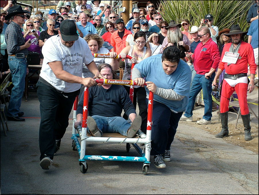
There are still some places that celebrate the road and revel in its history. Seligman, Kingman and Oatman, AZ, are probably the best known in the West. They have cultivated and refined their relationship with the road. Route 66 festivals, classic car runs and parades are just a few of the ways folks in these towns keep the idea of the road alive.
And then there is the merchandise. Posters, plaques, T-shirts, jackets, calendars, glasses, coffee mugs, coasters and a whole lot more have the various Route 66 symbols emblazoned on them. They are sold at gift shops, gas stations, diners, drug stores… well, almost anywhere there is an open shelf. These souvenirs of the time spent on the road go nationwide and worldwide and help recall the magic of the road.
United States Highway 66 still holds a special mystique in the hearts of travelers worldwide. It’s still America’ sentimental Main Street from Chicago to the coast...
…while it is still the quintessential road of our culture and history, the reality of it today is far different…
The Photographs: East from Kingman

The Kozy Trailer Park’s distinctive A-frame office was originally part of the Nickerson Farms restaurant chain that served travelers on Rt. 66 from the 1960s through the early 1980s. Nickerson Farms restaurants also sold Skelly gas, oil and car care products. The Kozy Trailer Park office, just east of Kingman, AZ, is reportedly the only Nickerson Farms building still in use.

Hackberry, AZ, started as a mining town and by 1875, the Hackberry Silver Mine was in full swing. The town was also a water stop for the railroad. The Hackberry School, built in 1917, was in continuous use until 1994.

Just east of Hackberry is the foundation of one of the many service stations that served the traveling public along Rt. 66 until the completion of Rt. 40 which bypassed the area. With just dirt driveways leading into and out of the station, the desert has easily reclaimed the site.

Orlando Motel in Truxton, Az., was built and operated by the Orlando family of Peach Springs. It appears the motel was built in the early 1960’s and was in operation through the 1980’s. The motel is now for sale and, while the building appears to be usable from the outside, a fire some time ago gutted much of the office.

If you are totally lost, this directional sign at Cowgill’s Gas ‘n Grub in Truxton, AZ, can get you pointed in at least the right general direction. Facing the sign, Chicago, the eastern start of Rt. 66, is to the right while Los Angeles, the western end of Rt. 66, is to the left.
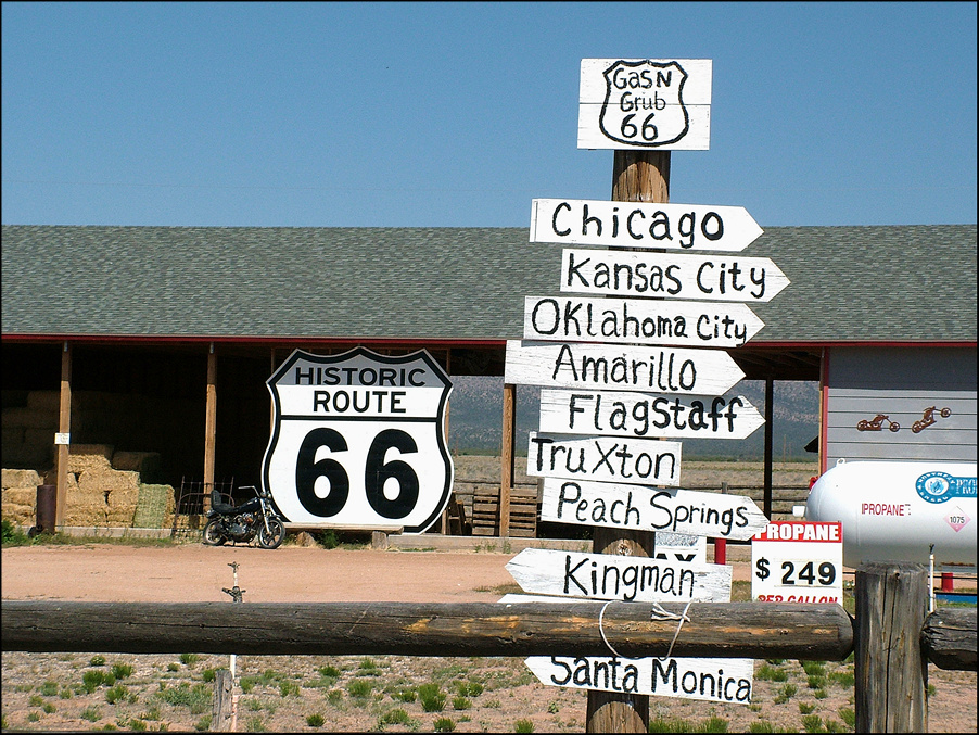
This collection of directional arrows at Cowgill’s is a bit more “destination specific” but has no distances to the locations. The sign lists some of the cities mentioned in Bobby Troup’s 1946 ode (Get Your Kicks on) Route 66. The song was originally recorded by Nat King Cole. The most recognized version is by The Manhattan Transfer.

While this location in Truxton, AZ, may have been “Roy’s Gas” at one time, it seems that the business plan changed at some point. They couldn’t decide what they were selling so they tried to appeal to everyone. Maybe it was art made of junk. Maybe it was junk masquerading as art. We’ll never know and it’s one of those mysteries of the road.
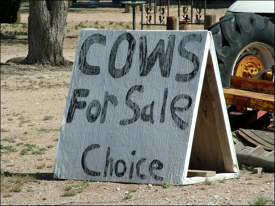
It is unclear if the cows for sale are “choice” or if the purchaser would be able to select the cows of their “choice”.

Oscar Ostermann, who was from Sweden, built the Peach Springs Shell Station in 1932. The station offered gas and repairs but was also a gathering spot for local residents. The station was placed on the National Registry of Historic Places in 2012, and was still in use up to several years ago. It is now owned by the Hualapai Indian Tribe.

Seligman, AZ, which celebrates its Rt. 66 heritage in every way. Through the efforts of local barber Angel Delgadillo, the Rt. 66 Association of Arizona was formed in 1987, just a few years after United States Highway 66 had been decertified. The association preserves the history and importance of the road.

Seligman, AZ, has held Rt. 66 as a centerpiece of its community for some time . Through Delgadillo's efforts, there are now Rt. 66 associations in every state the road traversed. Through the association's lobbying, much of the former U.S. Highway 66 has been re-signed as Historic Rt. 66 and various alignments of the route preserved.

An open-air cafe on Rt. 66 in Seligman, AZ, attracts locals and tourists alike. The Rt. 66 Association of Arizona is responsible for having the longest continuous section of Rt.66, the 158 miles between Kingman, AZ, and Seligman, AZ, designated an Arizona Historic Road and an All-American Road, the highest national designation possible.

Even though it is less than 500 feet off the Rt. 66 roadway, which later became Interstate 40, travelers did not stop at this motel. Such was the fate of many travel-oriented businesses when the newly completed high-speed interstate highways lured travelers to destinations which were always “just a little farther down the road”.

Although relatively modern in design, style and layout, this secluded log home, which sits well off the road, was abandoned by its owners some time ago. It now provides shelter only for small animals and birds.

The Parks Old Route 66 Deli & Café has been open since 1906, well before the establishment of Rt. 66. The business is at the intersection of Old Plains Trail (which predates Rt. 66) and the first road to Grand Canyon. As can be imagined, the café and deli has always been a meeting place for local residents.

The Twin Arrows Trading Post was one of those quirky, unique roadside attractions that sprang up along Rt. 66, almost becoming a destination in itself. Twin Arrows was located in the middle of nowhere. Travelers could order a meal at the café, which some say pre-dated the trading post, and then pick up souvenirs and snacks “for the road”.

Travelers would ‘gas up’ at Twin Arrows for the trek across the desert where the next stop was, at best, uncertain. It is impossible to say when Twin Arrows became a ‘full-service destination’ but it closed in 1995. Built on a State Lands concession, the property was relinquished to the State of Arizona when it closed and has remained unchanged.

Not visible to the general traveling public on what is now Interstate 40, the interior of the Twin Arrows buildings have served the needs of transient artists who see the unused walls as huge, sometimes larger-than-life, canvases. The dashes of light on the art work are from the now-deteriorated roof.

Meteor City Trading Post on Rt. 66 was originally called Indian Trading Post, but as the nearby Meteor Crater began to gain tourism, the owners of the trading post attempted to capitalize on their proximity. They renamed the trading post Meteor City and gave it an ‘American Indian’ theme.

The building to the left is the original trading post that was replaced by the dome in the 1970's. Meteor City closed for good after suffering several fires.

An abandoned gas station sits near Joseph City, AZ. With the continued development of the interstate highway system simple gas stations were replaced by ‘full service travel centers’ with restaurants, well-stocked convenience stores, auto accessories and fuel. These travel centers grew out of the truck stops that quickly lined the interstates.

The Jackrabbit Trading Post, another of the road’s quirky stops, has a ‘full-size-riding’ jackrabbit. The trading post appears to have changed hands several times but is still open as of this writing. Its sign, simply announcing “HERE IT IS” with the silhouette of the Jackrabbit, is almost as iconic as the Roy’s Motel sign in Amboy, CA.
Originally known as Hopi Village Indian Store & Cafe in the 1950’s, it became Howdy Hank's Hopi Village Indian Store & Café after ‘Hank’ bought it. When ‘Hank’ decided to leave business, new owners renamed it Sitting Bull's Indian Store. In 1991 it was converted it to a hay, feed and welding business. The business is inactive at this writing.

Ella Blackwell operated Ella’s Frontier Trading Post from 1947 until her death in 1984. Blackwell, who was known to be somewhat eccentric, alternately claimed the trading post was established in 1873 or 1940. In reality Fredrick Rawson opened the business in 1927 calling it The Last Frontier Trading Post.

The residential portion of Ella’s Frontier. Blackwell assumed total ownership of both the business and property in a 1955 divorce settlement. Blackwell, who was a student of the Julliard School of Music before becoming a trading post owner, was said to have kept a piano in the trading post. Whether she would serenade customers or not is unclear.

One of the rather substantial display cabinets used in Ella’s Frontier leans against an equally substantial log wall of the trading post. The property has remained untouched since Blackwell's death in 1984. The deterioration of the building is evidenced by the patches of sunlight streaming in through the exposed boards of the roof.

Originally called Canyon Lodge, this trading post and campground’s name was changed to Two Guns after Henry “Two Guns” Miller purchased the property. Two Guns grew into one of the most widely known tourist traps along the way. Two Guns boasted a road house and a small zoo featuring “mountain lions.”

Part of the “zoo” where Miller kept his “mountain lions”. It is not clear if Miller had other animals in his “zoo” or if he had more than just a few “mountain lions.” Between the “zoo” attracting children and the road house attracting adults, Two Guns was a popular stopping place on Rt. 66 for a while.

Miller's ambitious development featured the road house, “overnight facilities” (for the new practice of "automobile camping") and later rental cottages, a gas station and a trading post. But when traffic on Rt. 66 dropped off, first because of a realignment and then because of the development of the interstate, Two Guns was forced to close.

The Canyon Diablo/Rt. 66 bridge at Two Guns, AZ, allowed travelers to cross the steep-walled canyon in relative safety. The roadway leading to the bridge is a single-lane dirt road and the bridge surface is still dirt and gravel. This was an early alignment of Rt. 66 which was later abandoned for a more direct route through the area.

The WigWam Motel in Holbrook, AZ, was one of seven similar motels developed in the 1930’s. The motel operated through 1974 when slowing business forced it to close. In 1986 the motel was renovated and reopened. It was put on the National Register of Historic Places in 2002 and continues to operate at this writing.

Two themes have permeated Rt. 66 in Eastern Arizona and have carried over to I40- Native Americans and dinosaurs. According to this tableau dinosaurs and Native Americans existed at the same time and in the same place.

This abandoned home on Rt. 66 shows modern design and construction in a log- based home. It is a fairly large home and there are several out buildings on the property. The home had two fireplaces for heat and what appeared to be a screened-in porch. The dormer is an architectural feature allows light into the attic.

Rt. 66 was the main street of Cuervo, NM, and, as more traffic came through, the town grew. But Interstate 40 cut the town in half. Even with its own exit, traffic through the town dropped precipitously and Cuervo declined. Most of the population moved on. This well-built home sits abandoned on the north side of the interstate.

The Catholic Church in Cuervo may not be abandoned. The doors were padlocked, all of the windows were intact and the roof appeared to be both intact and recently repaired. Perhaps the hearty residents of the area still use it as a place of worship or a meeting place. The stone above the entry indicates the church was dedicated in April, 1915.

A home can be made out of almost anything that is sturdy and large enough. Here, an old railroad box car was converted into a home and it certainly has weathered the climate better than some of Cuervo’s adobe homes. It stands as testament to the residents’ ingenuity.

This long abandoned car was obviously a source of needed parts.

This abandoned adobe brick home has obviously seen better days. Without the constant maintenance this type of construction requires, the sunbaked, unfired brick will eventually weather and melt back into the desert from which it came.

The Cuervo Elementary School District Elementary School and District Office. The two-room school was staffed by two teachers who also served as principle and superintendent. One teacher taught first through third grades and was the school’s principle while the other teacher taught fourth through sixth graders and was the district superintendent.
The Photographs: West from Kingman

Oatman, AZ, was originally a mining town and, for a time, one of the largest gold-producers in the West. But a combination of mine closings and a disastrous 1921 fire sent the area on a slow decline. The town, which was almost completely abandoned in the 1960's, has remade itself into a delightfully tacky old-west tourist stop on Rt. 66.
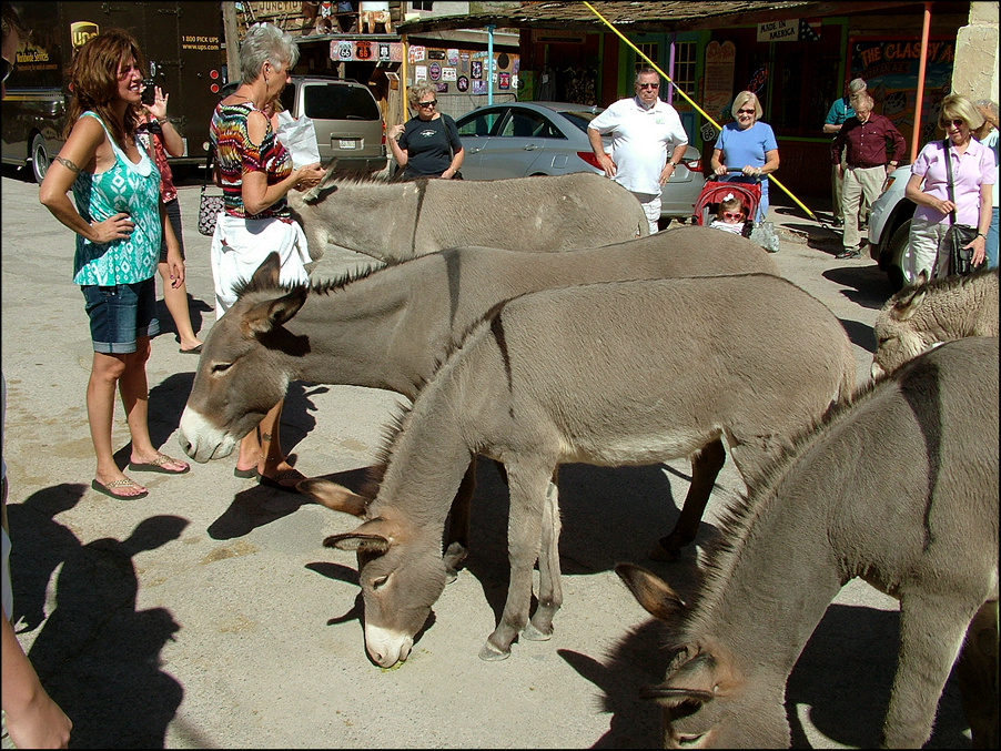
The wild burros that come into town to beg for food from tourists are part of daily life in Oatman. The burros are descendants of the pack animals released by early miners who did not want to take them as they moved on to the next mine. Merchants sell specially prepared, nutritious “treats” that tourists can feed the animals.
As a town, Oatman stages a number of events through the year ranging from bed races to the annual July 4th Sidewalk Egg Fry and the daily street “gun fights” that raise money for charity. It is reported that more than 500,000 people visit the town annually. To get there, tourists have to follow one of the original alignments of Rt.66.

The Glory Hole Antique Shop, which was once the town apothecary, is now the town’s Chamber of Commerce office and museum. It had its moment of fame when it was transformed into the Gold City Hotel for the 1963 John Ford epic “How The West Was Won.”

Just outside Oatman is a reminder of its past. This two-room miner’s cabin was abandoned long before the fire that almost destroyed it. The cabin became a haven for transients who were passing through the area. Cabins were built quickly and of almost any convenient material.
The 66 Motel in Needles, CA, which opened in 1946 as a six-room “motor hotel”, is now a complex of single-room apartments. They have kept the name to continue the tie-in with the road. There are other “66 Motels” in other places.

The 1931 realignment of Rt. 66 that provided a more direct route from Needles to Essex, CA, bypassed the town of Goffs and, when trains no longer stopped to take on water, Goffs declined quickly. The Goffs General Store appears to have closed prior to 2004 and may have been one of the last businesses in town.

This abandoned service station and tire shop was a much later addition to Essex, CA, but as traffic on Rt. 66 declined so, did the need for service. Despite its proximity to Interstate 40, travelers often chose to continue on to to other, more convenient locations.

This deteriorating building served two needs, as so many small-town structures did. It was a store in the front and the family residence in the back. After the interstate bypassed Essex, the business declined until the family simply abandoned the business, the home and the town.

All that is left of the Wayside Cafe, Camp and Store is the cafe. The business was started in the late 1920's as a cafe and auto repair shop. Later the filling station and store were added followed by the camp which featured rental cabins and a dry auto campground. The business contracted in the 1960's and 1970's until all that was left was the cafe.

All that remains of Cadiz Summit, CA, are the graffiti covered walls of the service station that was a "cool-down" spot for those traveling through the desert. Cars would often overheat on the long, slight but steady grade from Essex.. Like similar stops on the way, Cadiz Summit featured a cafe, a service and filling station, and a motel.

The steps to nowhere at Cadiz Summit. These steps led from the service station and restaurant to rental cabins that made up the motor hotel. Cadiz Summit was an active traveler’s stop through the 1940’s and 1950’s but declined in the late 1950’s.

Described as “one of the few shady places in this stretch of Rt. 66”, the current Chambless Store replaced a gas station and cafe that featured the "widest porch around". The original building, which was abandoned when the new store was built, was blown over in one of the fierce Mohave Desert windstorms that hits the area periodically.

Rental cabins made up most of the 'motor hotels' along Rt. 66. Those at the Chambless Market are extremely small with small windows that allowed for only limited air flow. Experienced travelers carried a small fan for these situations. The advantage of the cabin was the weary traveler could park right outside and not have to sleep in the car.
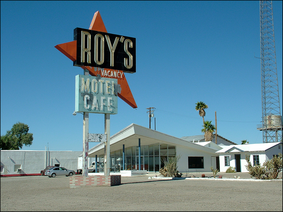
In 1938, Roy Crowl opened his motor hotel and cafe in the small town of Amboy CA. It featured unique, family-sized rental cabins. The retro-future office and now-famous sign were added in 1959. The sign, which has made a number of appearances in movies, television programs and ads, has become an icon for the secluded stopping place.

The family-size rental cabins at Roy’s motel. The town of Amboy, CA, including Roy's Motel, was once advertised as real estate for sale- motel, town and all. In 2005 Albert Okura bought the town for $425,000 and made a promise to preserve the town and reopen Roy's Motel. Keeping his word, Roy's Motel reopened on April 28, 2008.

Only the hanger of Amboy airport is left and it appears to have been unused for some time. The runway is overgrown with weeds and the surface has potholes. It appears the airfield was originally built in 1926 with a sod and gravel runway.

This abandoned gas station sits on Rt. 66 in Ludlow, CA. The town was originally a water stop for the railroads but, in 1906, a mining boom hit the area that lasted until 1940. After the mining boom, the town reinvented itself as a full- service stop for travelers, a strategy which lasted through the 1960's and into the 1970's.

As the traffic on Rt. 66 shifted to Interstate 40 which is literally within sight of this garage, Ludlow declined and most of the population of this once-mining, railroad and then traveler service town moved on, seeking their livelihood elsewhere.

Even though the Ludlow garage closed some time ago, the notices that the owners were not responsible for fire or theft and that they didn't cash checks are still emblazoned on the back wall of the garage.

This cafe suffered a fire sometime in the past. The minimal damage to the exterior of the building belies the fire's true impact. About 20 hearty residents remain in Ludlow, which has tried to reinvent itself again as a modern, full-service, rest area for the interstate traveler.

It appears that this building may have been a single family home at one time but it seemingly was converted into a boarding or rooming house, presumably to serve travelers on Rt. 66 who wanted to spend the night in Ludlow.

An abandoned mid-century modern home sits along Rt. 66. This home would be appropriate sitting on a manicured lot in suburban Los Angeles. Unlike homes further to the east, this home is stucco over frame construction rather than log. Given the overall condition of the home, it appears to have been abandoned some time ago.

While the exact use of this structure is unclear, it appears that it may have been a type of gazebo. What appears to have been a fire-pit is in the center of the structure and could have also been used as a bar-b-que.

The Bagdad Cafe in Newberry Springs, CA, has developed a truly world-wide following. International tourists have crammed the walls of this off-beat little restaurant with their memorabilia. The cafe was originally built in the 1940's as the Sidewinder and has served its basic burgers-and-chicken menu since it opened.

Part of the set for the Bagdad Cafe movie was this long abandoned motel just to the west of the cafe. It originally opened as the Henning Motel. One of its unique features is that it was built as a single building and not as a collection of cabins like Roy's Motel or the Chambless motor hotel.

Desert Market, on Rt. 66 in Daggett, CA, has been in the same location for more than 110 years and is a social center for a town that has all but disappeared. The building that is the market's current home, which survived a fire some years ago, was built in 1908. For some area residents, a trip to the market is a daily occurrence.

J. W. Burden and his son Charles ran the general store and post office in Helendale, CA. It became the community’s social center with neighbors meeting each other and exchanging news as they picked up their mail or purchased supplies. Later incarnations of the store included a small restaurant.

This now abandoned combination family home and business is near Victorville, Ca. The structure seems almost secluded despite its proximity to the Los Angeles metropolitan area. From here it is only a few miles to where Rt. 66 becomes just another four-lane street lined with burger joints and gas stations, going to work, or school or the mall.